Santa Barbara is surrounded by beautiful views with an ocean on one side and mountains on the other, so it is no wonder that there are plenty of great hikes all around the area. If you are in town and looking to see some views, we have cultivated a list below. Have a group coming in the future? Let us take care of the details and lead a hike for you! Here are some of the best likes in the Santa Barbara area:
Montecito Peak
Length: 5.8 miles
Level: Moderate to Difficult
This long and windy trail starts in near Cold Springs Creek and goes up the canyon before ascending up Montecito Peak. While the views are good along the way, the 360-degree panorama view at the top makes it all worth it. On a clear day, one can see many of the Channel Islands out to the west and all the way to Ventura down south, making it one of the most expansive views of the best Santa Barbara hikes.
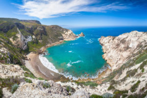
Potato Harbor
Length: 5 miles
Level: Moderate
This is definitely the most unique and stunning trail on our list. To start this hike you need to take Island Packers Ferry from the mainland to Santa Barbara’s offshore islands: The Channel Islands. (While you are there be sure to kayak in the sea caves as well!) Starting at Scorpion Anchorage on Santa Cruz Island, this hike follows the cliff side and offers unparalleled coastal views. This trail can be done as an out and back passing Cavern Point, or as a loop to the Upper Campground. You will most likely see the resident Channel Islands fox (about the size of a house cat) on the way, found nowhere else in the world. Walking from Scorpion Anchorage to Cavern Point and on to Potato Harbor, one has almost continual cliff side views, perfect for a chance to see some marine animals and snap scenic photos. The view over Potato Harbor looks like you are much closer to the tropics, with crystalline waters below and incredible rock formations jutting out of the coast. This hike is definitely one not to miss! Planning a day at the Channel Islands? Join us for sea cave kayaking in the morning and a hike to Potato Harbor in the afternoon! For other hikes on the Channel Islands, check out the National Park hiking guide.

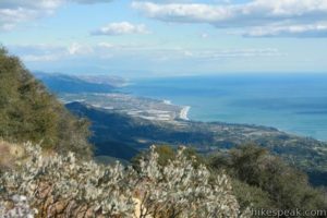
Inspiration Point
Length 3.75 miles
Level: Moderate
This one is a Santa Barbara hiking classic. It starts with at Tunnel Road with a moderate uphill through the Santa Ynez Mountains up to Jesusita Trail. The trail leads to panoramic views of both the ocean and downtown Santa Barbara. This is a great trail to really get a feel for the area and learn where you want to go next. This is the #1 iconic Santa Barbara hike, especially at sunrise!
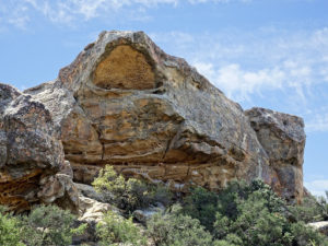
Lizard’s Mouth
Length: 0.5 miles
Level: Easy
This short hike leads to a unique rock formation (which the hike is named for) that overlooks Santa Barbara. The path wanders through boulders and brush before leading to “the lizard”. Nearby boulders make this a lovely area to lounge and enjoy the view. Fan of bouldering? Lizard’s Mouth is a climbers’ paradise with numerous routes to test your skills (don’t forget a crash pad!).
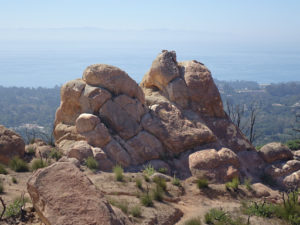
Saddle Rock Trail
Length: 3 miles
Level: Easy to Moderate
There are a couple different ways to do this hike. The trailhead is in Montecito and winds between a neighborhood before you take a right at the trail. Start by going up to Castle Rock with incredible views of the ocean above Montecito and a perfect rock to sit on (with the iconic heart shape below you). Then, decide if you’d like to carry on to the entire Hot Springs or Cold Springs trail, you can follow the hills for as long as you’d like. Check out the view of the Channel Islands (dubbed the “Galapagos of North America”) out in the distance.
Not easy.
Overview
Difficulty: Moderate • Mileage: 3
Elevation Gain: 750 ft. • Location: Front Country, Montecito
Features: Creeks, Loop Trip, Out & Back, Historical Point
User Type: Hiking, Dog Walking, Trail Running
Highlights
Saddle Rock Loop West
The Basics
Length : .75 mile up to the McMenemy Trail; 1 mile to start of Saddle Rock Trail; 1.5 miles to Edison Catway
Gain : 200’ to the Saddle Rock Trail; 750’ to the powerlines; 1100’ total elevation for the Girard Loop
Difficulty : Moderate to strenuous
Path : Dirt and paved roads on the first half, a very steep and rocky route up the Saddle Rock Trail.
Saddlerock / Hot Springs Trailhead: Parking has recently become so restrictive, they’re only spaces for 8 to 10 cars. If you park on the street you will be towed by the CHP. The rich neighbours hate hikers!